5-Days Weather Forecast of Dagarara Village of Lalganj block of Vaishali district of Bihar

We provide the most accurate weather forecast for Lalganj block of Vaishali district of Bihar for the upcoming five days, directly sourced from the India Meteorological Department.

Here's the day-to-day breakdown of the weather forecast

Clear Sky
Temperature Icon

27.88 °C

Rainfall Icon

59%

Additional Icon

0.04 mm

05-02-2025, Wednesday

Rainfall: 0.04 mm is likely to occur.

Maximum temperature likely to be 27.88 °Celsius and Minimum temperature is 17.15 °Celsius.

Maximum Relative Humidity likely to be 59 % and the Minimum Relative Humidity is 38.31 %.

Wind speed may go up to 3.48 kilometres per hour. With North Westerly direction

Cloud cover (Octa) i.e. the reading of the density of clouds may be 0.42.

Hence there is a possibility of Sky Condition: Clear sky.


Mainly Clear
Temperature Icon

24.9 °C

Rainfall Icon

51.36%

Additional Icon

0.05 mm

06-02-2025, Thursday

Rainfall: 0.05 mm is likely to occur.

Maximum temperature likely to be 24.9 °Celsius and Minimum temperature is 13.54 °Celsius.

Maximum Relative Humidity likely to be 51.36 % and the Minimum Relative Humidity is 20.92 %.

Wind speed may go up to 4.04 kilometres per hour. With Westerly direction

Cloud cover (Octa) i.e. the reading of the density of clouds may be 2.09.

Hence there is a possibility of Sky Condition: Mainly clear sky.


Cloudy
Temperature Icon

23.95 °C

Rainfall Icon

43.47%

Additional Icon

0.02 mm

07-02-2025, Friday

Rainfall: 0.02 mm is likely to occur.

Maximum temperature likely to be 23.95 °Celsius and Minimum temperature is 12.22 °Celsius.

Maximum Relative Humidity likely to be 43.47 % and the Minimum Relative Humidity is 21.86 %.

Wind speed may go up to 3.87 kilometres per hour. With Westerly direction

Cloud cover (Octa) i.e. the reading of the density of clouds may be 10.68.

Hence there is a possibility of Sky Condition: Cloudy sky.


Cloudy
Temperature Icon

25.08 °C

Rainfall Icon

48.45%

Additional Icon

0.04 mm

08-02-2025, Saturday

Rainfall: 0.04 mm is likely to occur.

Maximum temperature likely to be 25.08 °Celsius and Minimum temperature is 11.55 °Celsius.

Maximum Relative Humidity likely to be 48.45 % and the Minimum Relative Humidity is 22 %.

Wind speed may go up to 2.88 kilometres per hour. With Westerly direction

Cloud cover (Octa) i.e. the reading of the density of clouds may be 40.38.

Hence there is a possibility of Sky Condition: Cloudy sky.


Partly Cloudy
Temperature Icon

27.01 °C

Rainfall Icon

49.41%

Additional Icon

0.05 mm

09-02-2025, Sunday

Rainfall: 0.05 mm is likely to occur.

Maximum temperature likely to be 27.01 °Celsius and Minimum temperature is 12.09 °Celsius.

Maximum Relative Humidity likely to be 49.41 % and the Minimum Relative Humidity is 20.35 %.

Wind speed may go up to 2.64 kilometres per hour. With Westerly direction

Cloud cover (Octa) i.e. the reading of the density of clouds may be 4.29.

Hence there is a possibility of Sky Condition: Partly cloudy sky.


Rainfall Information : A total of 0.2 mm of rainfall expected in the coming week.

Weekly Weather Outlook

We understand the importance of staying informed about the weather for the success of your agricultural activities. That's why we're here to provide you with the latest weather information, including daily updates, 10-day forecasts, and real-time reports specific to your location. Here are the details of the Weekly Weather Outlook.

  • Minimum Temperature: The average minimum temperature for the week is approximately 13.31 °C
  • Maximum Temperature: The average maximum temperature for the week is reaching up to around 25.764 °C
  • Rainfall Potential: The average rainfall potential for the week is expecting approximately 0.04 mm of rainfall, which is vital information for your irrigation and crop management strategies.
  • Humidity Levels: The average humidity levels for the week vary, with a maximum averaging around 24.688 %, and a minimum averaging around 22%.

Wind direction: Degree to Direction conversion.

compass

Categories for Sky condition in Local Forecast

Sky condition Portion of sky covered with clouds (in Octa)
Clear sky 0
Mainly clear sky 1-2
Partly cloudy sky 3-4
Generally cloudy sky 5-7
Cloudy sky >7

List of Gram Panchayats under Lalganj Block in Vaishali

Achhichhi
Agahata
Agai
Ahirauli khizirpur
Akbalpur sahna
Akolhi
Alampur
Amawan
Ambara pashchim
Amilia
Arjunpur
Asainapur
Asau tikar
Asrhi
Atraila raja
Babhanpur
Bachawal
Bagharwa urf molnapur chak
Bahadurpur
Bahai
Bahrampur
Bairdih
Baladih
Balipur
Bami
Banarpur salehara
Bandai
Banna mau
Banwari
Bara gaon
Baraha
Bardiha
Baribojh
Barservwa
Basahi akbalpur
Basahi kala
Bastra raja
Basupur
Behta kalan
Beili
Bela
Belha
Bemoura mahesh khera
Berama bisambharpur
Bhadrikala
Bhavram bojhi
Bhebhaura
Bheda
Bhojpur
Bhuraki
Bishun khera
Byouhara
Chaki dih
Chanda
Chanda tikar
Chandevra
Charki kala
Chauki nasratppur
Chewar paschhim
Chewar purab
Chilaula
Chirikihit
Chitang
Chiutahra
Dagarara
Datauli lal ganj
Dauna
Delhupur
Devnathpur
Dewapur
Dhadhuwa gajan
Dhana bhad
Dhannipur
Dhasarda
Dhobaha devghata
Domanpur
Dubar kala
Dubar khurd
Etaila
Faizullahpur
Fakarudeenpur
Gadouli
Gahiri
Gangapur goghi
Gangasayar kala
Ganghara kala
Gardbard
Gegaso mu.
Gobardhanpur
Gokhari
Gondwa
Goura rupaipir alipur
Govindpur valauli
Haripur
Harni dehra
Hilalpur
Hulasgarh
Ismailpur barhati
Jagannathpur
Jagatpur bhichkaura
Jahatmandpur
Jaikar kala
Jamuwanwa
Janewa katra mau
Jhavar patti hardo
Jogapur barigaon
Kahala sikandarpur
Kaithi shankarpur
Kalapur
Kalichabad
Kanjahit
Kaotabujurg
Kapsetha
Karia gopalpur
Kasba deogaon
Katai
Kathauni
Kathwar
Katouli bujurg
Katouli khurd
Kaushlyapur
Kethola
Khaira kala
Khajur gaon mu.
Khajuri
Khaniara
Kharihat kala
Khetaura
Khumha devari
Kolkam kala
Korihara
Kothi
Kotwa sukulpur
Kumhraura
Lahangpur
Lalapur
Lalganj
Lalu mau
Lalupur
Madhopur dharang
Madhukarpur
Madipur
Maduri
Maha khera
Mahadev
Mahular
Maide mau
Majhiyar
Malpura
Manikpur kishunpur
Marahati
Matehana
May kharagapur
Medhawan
Medhra
Meharo jagdeeshpur
Mirza adampur
Mirzapur
Mirzapur urf toadhakpur
Mishrainpur
Mithapur barhaiya
Mubarakpur
Munsipur
Mustafabad belahni
Nadauli karaundi
Nandapur
Naraina kala
Narayanpur nevada
Narsinghpur
Nathmalpur urf vishambharpur
Newardhiya
Nonipur urf nai koat
Pachokhar
Paharpur
Pajra
Pakari khurd
Paliyavir singhpur
Pandari
Paraspur
Parsaura jagdeeshpur
Patar kala
Patluki
Payagipur
Pichura
Pure bansi
Pure ichharam
Pure roop
Pure tilakram
Raamgarh khas
Radmo
Raipurtiyae
Rajai
Rajapur
Rajauli
Ramgarh raila
Rampur badoona
Rampur kamta prasad
Rampur katharwa
Rampur madawa
Rampur wasit ali
Ran gaon
Rangauli
Ranibari
Ranipur
Rasoolpur jaydrath patti
Rasulpur duadhara
Raza devalpur
Rehi
Rewari pasiya khera
Rewosha
Rohara
Saimbasi2
Sakatpur
Salamepur
Samapur
Sarai bairiha khera
Sarai janmati
Sarai raijoo
Saraijagat singh
Sarangpur
Saray narayansingh
Saripur
Semer paha
Semri kala
Shafipur urf sarupahua
Shahpur
Shekhpur bachhauli
Shobhawapur
Sidhauna
Sikraura
Sondasi
Sophipur
Srikantpur
Tarafqazi
Tarapur
Tendua kala
Tenduhani
Tharparasiya
Tirauli
Tulsi
Turkha
Ubarpur lakhmipur
Udharanpur
Udwa mau
Uga bhad
Umari shree
Upenda
Usarauli
Usari khamharia
Uska
Utara gauri
Yusufpur

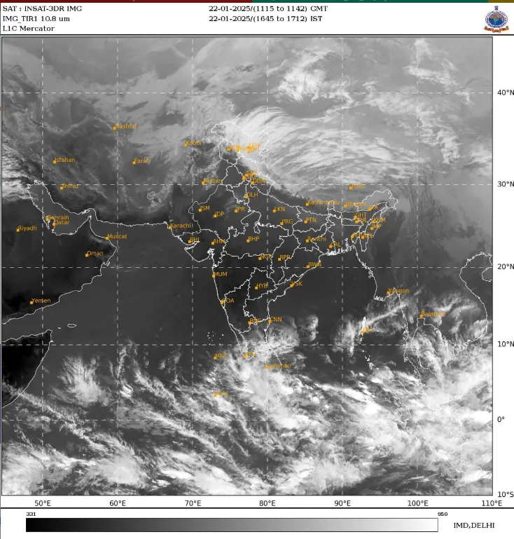
Satellite View of Weather Situation

Subject: Under the influence of Western disturbance, light to moderate rainfall/snowfall likely over Western
Himalayan Region and light rainfall over adjoining plains on 22nd & 23rd January, 2025.

Realised weather during past 24 hours till 0830 hours IST of today

  • Dense to very dense fog (visibility< 50 m) reported in some parts of East Uttar Pradesh;
    in isolated pockets of Haryana, West Uttar Pradesh, Bihar, Odisha and dense fog (visibility 50-199 m) reported
    in isolated pockets of Jammu-Kashmir, Assam & Meghalaya and West Bengal & Sikkim.
  • Visibility reported (<200 m) (in meter): Haryana: Karnal 0; East Uttar Pradesh:Gorakhpur,
    Bahraich 0 each; West Uttar Pradesh: Najibabad 0; Bihar: Purnea 0; Odisha: Chandbali 0; Jammu-Kashmir: Kupwara
    50; SubHimalayan West Bengal & Sikkim: Bagdogra 50, Cooch Behar 50; Gangetic West Bengal: Durgapur 50, Bankura
    50, Panagarh 50; Assam & Meghalaya: Barapani 80, Cherrapunji 100.
  • Light rainfall/snowfallat a few places occurred over Jammu-Kashmir-Ladakh-Gilgit-
    Baltistan-Muzaffarabad.
  • Weather Systems, Forecast and warning:

    • The Western Disturbance as a cyclonic circulation lies over Punjab & neighbourhood in lower tropospheric
      levels. The induced cyclonic circulation lies over Haryana & neighbourhood in lower tropospheric levels.
      Another cyclonic circulation lies over southeast Rajasthan and neighbourhood in lower tropospheric levels.
      Another Western Disturbance as a trough in middle & upper tropospheric westerlies runs roughly along Long. 65°E
      to the north of Lat. 30°N. Under the influence of these systems:
    • Isolated to Scattered rainfall/snowfall very likely over Western Himalayan Region till 23rd and isolated
      rainfall likely over Punjab, Haryana, Chandigarh & West Uttar Pradesh on 22nd & 23rd and Rajasthan on 22nd
      January.

    • ✓ Thunderstorm activity at isolated places likely over Himachal Pradesh, Uttarakhand, Haryana, Chandigarh
      and West Uttar Pradesh on 22nd January.

    • ❖ Thunderstorm activity at isolated places likely over Arunachal Pradesh, Assam & Meghalaya and Tamilnadu
      Puducherry & Karaikal on 22nd January.

    Cold Wave Warnings:

    Cold wave Cold Wave conditions very likely in isolated pockets of Jammu-Kashmir-Ladakh-Gilgit-Baltistan-Muzaffarabad and Himachal Pradesh on 23rd & 24th January.
    Cold Day Warnings:
    Cold Day conditions very likely in isolated pockets of Himachal Pradesh on 23rd and Bihar on 22nd & 23rd January.
    Dense Fog Warnings:
    Very Dense fog Conditionvery likely to continue to prevail during night/early morning hours in isolated pockets of East Uttar Pradesh on 22nd January.
    Dense fog Condition very likely to continue to prevail during night/early morning hours in isolated pockets of Jharkhand, Assam & Meghalaya, Nagaland, Manipur, Mizoram & Tripura till 23rd; Rajasthan, West Bengal & Sikkim, Bihar, Odisha till 24th; West Uttar Pradesh till 26th; East Uttar Pradesh during 23rd-26th January.
    Fishermen Warnings:
    Fishermen are advised not to venture into Comorin area & adjoining Gulf of Mannar on 22nd & 23rd; south of Sri Lanka
    coast & adjoining southwest Bay of Bengal, northwest Arabian sea adjoining Gulf of Oman on 22nd January